

For friends who want to know how to build a station, how to build a station, how to build a station, how to do it, how to do it, how to do it, and how to do it, it's a very interesting question, and the following is a question for you to look at。
In the world of precision engineering measurements, the whole station is like the "flammator's eye" and the high range is the dimension of the soul that constructs three-dimensional spatial coordinates. A mastery of how the entire station is built and how it can be set up accurately is key to unlocking three-dimensional precision data in many areas, such as topographic mapping, construction and road engineering. This is not only a step in instrumentation, but also an art of space, data and precision. This paper will provide an in-depth analysis of these two core processes, which will lead you from principle to practice, to overcoming the challenge of high-range measurements。
I. High-range construction stations: precise anchors for measuring benchmarks freeze
The first step in the measurement of the full range is to establish a solid measurement benchmark, namely, the “high range of the station”. The process is to give a unified “altitude” starting point for all subsequent measurements, the accuracy of which directly determines the reliability of the final outcome。
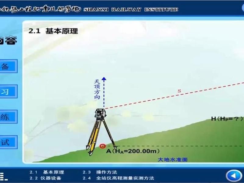
The classic method is to install instruments at control points of known coordinates (including high range). The operator is required to match the whole station to the center of the station with precision, and then to take a measure of the instrument's height — that is, the vertical distance from the centre of the ground control point to the centre of the whole station. This seemingly simple step is essential, and its error is transmitted directly to each subsequent point. Volumes are taken using steel rolls and ensuring that the height is vertical, with multiple measurements of averages to reduce errors. Subsequently, the three-dimensional coordinates of the stations (n, e, z) and the high number of instruments just taken are entered sequentially in the station menu for the full station. As a result, a spatial survey coordinates system has been established within the instrument, with the station as its starting point。
In the case of an instrument installed on an unknown point, the station altitude can be determined using the “rear encounter” method. This approach gives great flexibility to measurement. The instrument may be mounted at a position of any good view, by observing the slopes and vertical angles of two or more known high-range points, and automatically deciphering the high-range and peaceful coordinates of the station by means of an internal instrumentation program. In this process, the input logic of high instrument and high prism may differ from that of tradition and require a deep understanding by the operator of the core principle of "station altitude + instrument high-presence = constant" and flexibility in combining input parameters to ensure the correct calculation of the baseline。
Regardless of the method used, after the construction of the site is completed, a post-censorship check is required. Is the measurement of the height of another known point against the known value. If the margin exceeds the permitted range, it is necessary to check whether the instrument is high, the prism is high or the station is re-established. This step is to put an end to errors and to ensure that the follow-up is carried out smoothly。
Ii. Coordinate sample: the design of the blueprint “cruising” on the ground
If a station is set as a baseline, the high-range sample is a precision " project" of the high-range data on the design drawings to a given location in the real world. This is the core technology for engineering work, such as road-based digging, high control of floor plates, plumbing, etc。
Coordinate sampling is one of the most common features of the entire station. The operator first enters the design coordinates (n, e, z) of the place to be displayed in the whole station template. The instrument automatically calculates the horizontal angles to be rotated and the distance to be measured, based on the coordinates of the station and the coordinates of the sample points. The direction of the telescope's axis is the orientation of the sample point when the direction of the direction of the axis is to be seen in the direction of the rectangular range, with a horizontal angle margin of zero. The cameraman moves the prism around this direction, observing the distance margin on the screen, where the distance difference is also zero, the midpoint of the prism is at the plane position of the sample point。
Once the plane position is determined, it enters the critical high-range sample chain. Placing the prism close to the sample point, allowing the entire station to conduct measurements at the centre of the prism. The instrument screen shows a realistic altimeter of the current position of the prism. A high margin is derived by comparing this measured value with the design high range value. Based on this margin, the command division mirrors adjust the height of the prism above and below (e. G., slide the prism on the middle pole). When the altitude is measured in accordance with the design height, mark the corresponding height at the bottom of the middle pole or at the centre of the prism, which is the required design height。
The entire process requires that the station and the sampling site have a good view and that the instrument is high and the prism is accurate. For batch point sampling, all sample coordinates can be pre-positioned into the instrument, which can be called in a sequential manner and greatly improves external efficiency。
Suspended measurements and sampling: addressing “unreachable”
In engineering practice, sites to be detected or sampled are often located at high altitude (e. G. Bridge floors, high pressure lines) or deep pits (e. G. At the bottom of the base) and cannot be directly placed in the prism. At this point, the “suspension measurement” and “suspension sample” functions show their magic。
Suspend measurements permit the measurement of altitude at points where it is not possible to directly locate the prism. The rationale is to place the prism directly below (or directly above) the target to be measured and to take the prism to a precise level. The full station gauges the prism, gauges the slopes and the sky ceiling, and re-rotation telescopes target and measure the sky ceiling. The instrument automatically calculates the altitude of the target point based on geometric triangles. This method managed to avoid the difficulty of direct contact and extended the range of measurements for the entire station。
Surfing is a reverse application of this principle, which is used to present a particular high field at a high or low point where no mirror is available. For example, in the construction of high-pressure lines, there is a need to ensure that the directional distance to the ground corresponds to the design safety altitude. At the time of operation, the prism is placed below the target lead line on the ground, taking the prism high. Enter the height value (e. G., the height of the steering line off the ground) that needs to be sampled in the all-stationer suspension sample mode. The mirror then moves a visible sign (or laser pen) up and down in the direction of the target lead line, and when the instrument displays an altitude margin of zero, the mark is located at the design height. This approach frees up absolute reliance on the position of the prism and demonstrates the robust adaptability of the entire station to intelligent measurements。
Iv. Irregular taming: the method of precision improvement
The spirit of the high measure is precision. Inevitably, full-station triangle elevations are affected by multiple sources of error, which can only be tamed and reliable data obtained if they are understood and effectively controlled。
Vertical angle observations are the primary enemy. When the angle of the line of view (vertical angle) is too large, a small angle error leads to a large high margin error. When transmitting a high range, as far as possible, observations should be made at the smaller angle of the view. Atmospheric decomposition, like an invisible hand, bends the light path and influences vertical angle observations. The effects are particularly significant when the temperature differentials are high in the morning and evening and near-ground air density gradients change dramatically. The choice of weather conditions to be stable and to be observed close to noon is an effective strategy to reduce photometric error。
The distance error is linearly magnified by a high error. According to the law of error transmission, the longer the margin, the greater the impact of the margin error on the high difference result. Where conditions permit, the distance between the station and the target point shall be as short as possible. High instrumentation and high target (prissor high) volume error leads directly to high difference results at a ratio of 1:1. This error shall be minimized by using a measured steel roll rule, using the correct quantity and taking two separate scales, and taking an average of no more than 3 mm for each margin。
The vertical indicator difference (i-angle) of the instrument also leads to system errors, which require periodic verification and correction of the instrument. In situations where precision requirements are very high, measurements of direction (i. E., round-trip measurements) or intermediate methods can be used to offset or mitigate some of the error effects using observation procedures themselves。
V. Freedoms and cross-border assessment: the high-level text of affairs
In complex terrains or sites with restricted general view conditions, traditional known site-based approaches may be difficult to move. The "free station" and "to-side measurements" become the master cards of surveyors。
Free stationing, or “back postation”, allows the entire station to be mounted at any point of convenience at unknown coordinates. Through an angle and distance observation of multiple (usually more than two) known points, the instrument can decipher the three-dimensional coordinates (including high range) and orientation parameters of the station at the same time. This approach is completely free of reliance on the location of traditional control points, especially in situations where bridges, tunnels, indoors and other known points are difficult to use or to see. On the high-range transfer, it also follows the parameters of a specific logical setting and achieves an integrated free station of plane and high-range。
Marginal measurements provide a means of pure capture of high levels. The full station frame is located at any location and does not require input into station heights, instrument heights and prisms (or any assumptions). Maintaining the prism height by measuring the vertical angles of points a and b (or reading the trigonometric high difference dz), respectively, the difference between the observations of the two points being the high difference between points a and b. This method, which completely circumvents errors resulting from high-measured instruments and high-presence prisms, is extremely simple and applies particularly to standard route measurements or to situations where only two points are required. The essence of this is to use the whole station as a combination of an electronic long- and long-range meter, with a high margin extrapolation based directly on basic observations。
Vi. Operational process fine-tuning: a perfect line of action from preparation to completion
A successful measurement project began with careful preparation and finally ended with a rigorous closure. The integration of station-building and sampling into a full operational process ensures that nothing is lost。
Prior to the operation, coordinates and high-range information must be collected for all known control points, and instrument batteries must be checked for electrical capacity and equipped with support equipment such as scaffolds, prisms, medium rods, steel rollers, record books, etc. Upon arrival at the site, the site should first be taken: the site should be selected in a position that is solid in soil, has a good view and is conducive to safe operation; the sample point path needs to be planned in advance to ensure that it is fully measurable。
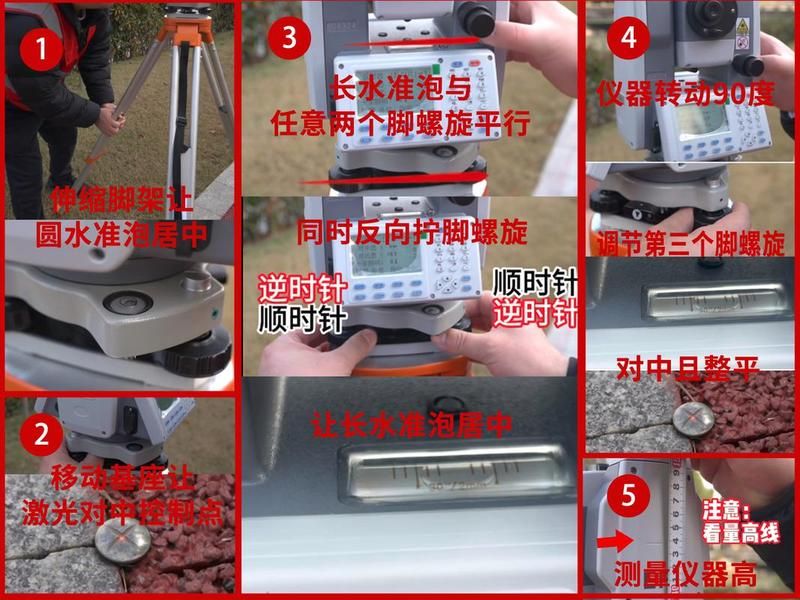
Installation of instruments is fundamental. The tripod was expanded and the station was placed at the centre of the square. Precision is achieved by neutralizing the medium by optical or laser, and by adjusting the helix of the foot so that the long-level tube is neutral in any direction. Moderate to flat is subject to repeated adjustments until both meet the requirements. Subsequently, the instrument was carefully measured with a roller foot。
Then we're going to build a station. Enter the station number, coordinates, instrument height. Then you follow the rear view point and enter the rear view point information for orientation. It is essential that a back-to-back inspection be carried out to measure the coordinates of another known point against the known values, and that follow-up work be initiated after confirmation。
When sampled, draw or input coordinates of the sample point from the instrument. (b) to guide the mirrorer to the plane position by angle and distance, and then to adjust the altitude of the prism by observation, until such time as the altitude measure corresponds to the design height and is marked. Upon completion of the sample of each point, the test may be repeated for verification。
Upon completion of all work, all target points should be checked and documented. Turn it off, and keep your instruments and accessories safe. Return to the industry, collate the data in a timely manner, collate the results and complete the preparation of the measurement reports. This is a lifeline for measuring quality and efficiency from preparation to implementation。
This is an introduction to how the whole station is built and how the whole station is set up. It is hoped that this will help friends who want to know how to build the site。
Title: how the whole station is built, how the whole station is placed; link: https://zwz66. Cn/jianz/355517. HTML。